Navigation

  • Skip to Content
NTNU Home

Department of Manufacturing and Civil Engineering

  • Studies
    • Master's programmes in English
    • For exchange students
    • PhD opportunities
    • All programmes of study
    • Courses
    • Financing
    • Language requirements
    • Application process
    • Academic calendar
    • FAQ
  • Research and innovation
    • NTNU research
    • Research excellence
    • Strategic research areas
    • Innovation resources
    • PhD opportunities
  • Life and housing
    • Student in Trondheim
    • Student in Gjøvik
    • Student in Ålesund
    • For researchers
    • Life and housing
  • About NTNU
    • Contact us
    • Faculties and departments
    • Libraries
    • International researcher support
    • Vacancies
    • About NTNU
    • Maps
  1. Department of Manufacturing and Civil Engineering
  2. Laboratories
  3. Geomatics

Språkvelger

Norsk

IVB - Geomatics

×
  • Home
  • Studies
  • Laboratories
    • Additive Manufacturing
    • Building information modeling (BIM)
    • Building materials
    • Geomatics
    • Machine workshop
    • Manulab
    • Polymer composites (ASEM)
    • Renewable energy
    • Technology design and management
    • Virtual and augmented reality
  • Research
  • Employees
MENU

Laboratory for Geomatics

DEPARTMENT OF MANUFACTURING AND CIVIL ENGINEERING

Laboratory for Geomatics

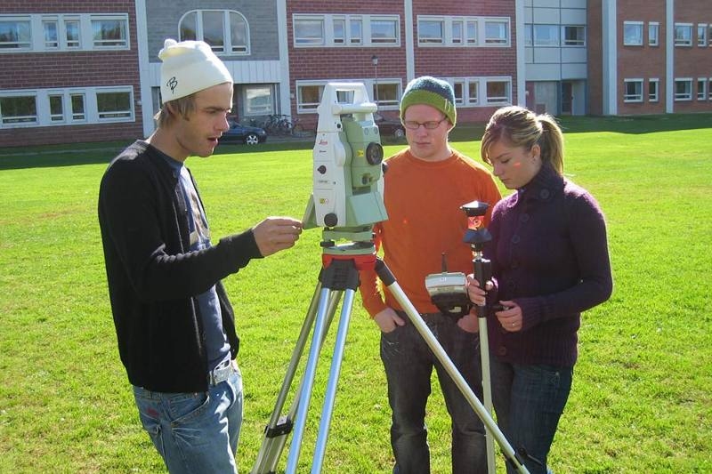
Geomatics labs are for surveying, geographical information systems (GIS) and building information modeling (BIM).

We learn about and test different types of surveying equipment and software. We process the collected data on personal computers and on NTNU’s desktop computers, they visualize in both 2D and 3D (VR).

Picture of students with equipment for survey


Access and opening hours

Geomatics labs are available for geomatics students and other fields of study that have subjects related to geomatics. Lab and equipment are available 24 hours a day except during the Christmas holidays and summer holidays.

What can you do

Test instruments and software.

Equipment and materials

Surveying instruments: Leica 100M (Levelling equipment), Leica TS16 (total station), Leica MS60 (Multi-station), Leica GS16 (GNSS), and Leica P40 (laser scanner).

Drone: Phantom 4 Pro

PCs: Alienware Aurora

Training and safety

Training with surveying instruments and software are part of the education. No separate courses have been set up.

Research

No research is ongoing. There are some scheduled research projects for 2019/20.

Innovation and entrepreneurship

Bachelor and master's students are involved in projects with advisory consultants.

Other

An equipment agreement with Leica Geosystems provides updated equipment.

Where is the laboratory?

Where is the laboratory?

Map: Geomatics lab

person-portlet

Contact

Morten Eggum
Staff Engineer
morten.eggum@ntnu.no
NTNU
Studies
  • Master's programmes in English
  • For exchange students
  • PhD opportunities
  • Courses
  • Career development
  • Continuing education
  • Application process
Contact
  • Contact NTNU
  • Employees
  • For alumni
  • Press contacts
  • Researcher support
Discover NTNU
  • Experts
  • Vacancies
  • Pictures from NTNU
  • Innovation resources
  • NTNU in Gjøvik
  • NTNU in Trondheim
  • NTNU in Ålesund
  • Maps
About NTNU
  • NTNU's strategy
  • Research excellence
  • Strategic research areas
  • Organizational chart
  • Libraries
  • About the university
Services
  • For employees
  • For students
  • Blackboard
  • Intranet

Norwegian University of Science and Technology

Use of cookies
Accessibility statement (in Norwegian)
Privacy policy
Editoral responsibility
Sign In